It’s nothing short of amazing how satellite altimetry enables us to determine surface currents. They are particularly effective at mapping out the energetic mesoscale (10-100 km) velocity field and how it varies over time. This includes all features that have a surface elevation that reveals the geostrophic balance between pressure and velocity. The literature is rich with altimetric studies of western boundary currents, coherent vortices and planetary waves. It really is remarkable. The frustrating part is that this vision is limited to the surface. It is also limited in scale: small scale motion is not geostrophic, and basin-wide scales require accurate knowledge of sea level relative to an ocean at rest. Even if the ocean were a simple 2-layer system we would be challenged unless we knew exactly what the sea level would be for an ocean at rest (which we don’t), and because the barotropic and baroclinic modes have different surface expressions. So, what to do?
Starting 30+ years ago several of us have instrumented merchant marine vessels with acoustic Doppler current profilers (ADCPs) to scan upper ocean currents along their routes. The beauty of this approach is that we capture all scales of motion, from the submesoscale to basin-wide gyres with equal accuracy (e.g. Rossby et al., 2017). The price we pay for this approach is poor temporal resolution, limited as it is to the vessel’s schedule. But I would submit that if the focus of the program is on seasonal and longer time scales and trends then weekly or monthly sampling will suffice (as with the above reference). I’ve said this before and I’ll say this again: This is the beauty of working with the merchant marine, they have a continuing presence on the high seas we cannot possibly match with research vessels, gliders or other autonomous vehicles.
Being a North Atlantic oceanographer with an interest in the Atlantic meridional overturning circulation (AMOC), I envision instrumenting MM-vessels that operate between Europe, Iceland, Greenland, and North America with ADCPs much like we did on the Nuka Arctica (above reference) with preferably 38 kHz ADCPs that can profile currents to ~1200 to 1500 m depths. This would allow us to map out the velocity field and transport down to and including the main pycnocline. Such a network would capture the entirety of the north-flowing upper branch of the AMOC, its spatial distribution, strength, and variability. The cost-effectiveness of this approach compared to any other is not in question, and we know from experience that MM-operators are willing to help.
This figure illustrates shows the mean velocity field normal to the cruise vessel Explorer of the Seas’s route between New Jersey and Bermuda. It gives you a vivid idea of what is possible.
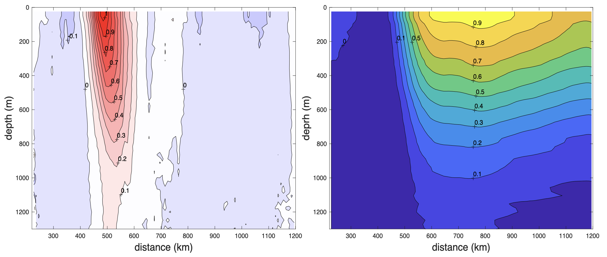
The left panel shows the mean velocity field based on 57 crossings; the right panel shows the geostrophic dynamic height field obtained by integration of the velocity field from left to right. No hydrography or altimetry was needed to construct this figure. In fact, it might be instructive to compare the dynamic height field at the surface with the altimetric field along the route.
Imagine returns like this across the North Atlantic. It could be motivated by a need to get a better and sustained handle on the AMOC. In a few short years you would start to have an unparalleled very high-quality data base for study. And the effort can continue for as long as you like – or you come up with a better idea! To profile currents to as deep as possible means either a 38 kHz ADCP or possibly the new, smaller but unproven Pinnacle. The 38 unit has a good track record, but it is very heavy and requires a costly sea chest to fabricate and weld into the hull. I wrote about this earlier that perhaps the ADCP can be built using carbon fiber instead of marine brass and mounted externally.
These are tough times in science, but perhaps we can use the time to regroup? We need to create a framework or culture that embraces a partnership with the merchant marine for ocean study. It’s not just ADCPs, it can be whatever tools we can develop optimized for ocean study in the MM-environment (Andres et al., 2025). We all agree that sustained observation is essential, but we lack the institutional infrastructure to realize this need. This is perhaps the overarching challenge facing us.
Rossby, T., G. Reverdin, L. Chafik, and H. Søiland (2017) A direct estimate of poleward volume, heat, and freshwater fluxes at 59.5°N between Greenland and Scotland, J. Geophys. Res., 122, doi:10.1002/2017JC012835.
Andres, M., T. Rossby, E. Firing, C. Flagg, N.R. Bates, J. Hummon, D. Pierrot, T.J. Noyes, M.P. Enright, J.K. O’Brien, R. Hudak, S. Dong, D.C. Melrose, D.G. Johns, and L. Gregory (2025). Monitoring impacts of the Gulf Stream and its rings on the physics, chemistry, and biology of the Middle Atlantic Bight shelf and slope from CMV Oleander. In Frontiers in Ocean Observing: Marine Protected Areas, Western Boundary Currents, and the Deep Sea. E.S. Kappel, V. Cullen, G. Coward, I.C.A. da Silveira, C. Edwards, T. Morris, and M. Roughan, eds, Oceanography 38(Supplement 1):54-60,
https://doi.org/10.5670/oceanog.2025e108.