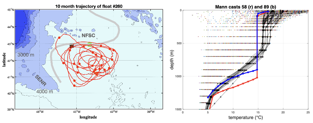
The Mann Eddy is a body of recirculating water driven by a branch of the Gulf Stream that turns north around the SE Newfoundland Rise (SENR). Known as the North Atlantic Current (NAC), it flows at first NW curving to the north before the blocking effect of the Newfoundland Seamounts forces it to curve clockwise to the east. This rapid current whose path is defined by bathymetry to the south, west, and north, sets up what appears to be a permanent anticyclonic circulation. It is not a free-standing body of circulating water as we usually envision coherent eddies, but one trapped and defined by the moving sides, the NAC, to the SW, W, and N. See the trajectory of float #260 below.
The figure shows the bathymetry and the trajectory of an isopycnal RAFOS float that remained trapped the eddy for its entire 300-day mission at depth during time it made 12 loops, most of them taking about 14 days. The red dots are 20-day markers, and the green and black markers indicate the start and end of the mission. Note that the trajectory does not exhibit the tight circular motion we normally associate with coherent eddies. This suggests it is actively interacting with the NAC (the gray band indicates its mean path) which itself, although guided by bathymetry, is wobbling or wiggling as it flows through the region. It is striking that the NAC turns far to the east to flow around the sparse Newfoundland Seamount chain (NFSC in the figure). The NAC, in effect the poleward branch of the Atlantic meridional overturning circulation, transports warm salty water. The waters west of the NAC transport cool fresh water to the south (the Labrador Current). Because its path is defined by the bathymetry the large meanders do not translate downstream as in the Gulf Stream suggesting that it may be a better barrier to cross-frontal exchange.

Ever since I read Cedric Mann’s paper eons ago I’ve known that it has a deep pool of well-mixed water and a correspondingly deep thermocline. In preparing this post I scanned the EN-4 hydrographic data set for more recent data. These are shown in the right panel below. I was stunned to see how extreme the profiles from Mann’s 1964 survey are: between 100 and roughly 1000 m the temperature increases from 14.73 to 14.83°C, suggesting very near adiabatic conditions to far greater depths than seen at any time since. I had no idea at the time that they were so extreme, but almost certainly these reflect the severe winters of the early 1960s at which time the NAO index was at its extreme negative. I didn’t see the Mann data in the EN-4 archive, but he writes in his figures the actual temperatures in the thermostad. The temperatures above and below I’ve estimated from the figures in his paper. A geostrophic estimate of the eddy strength relative to 2000 m using station 58 and a group of hydro-casts immediately to the east of the eddy results in ~74 Sv recirculating to the south.
It seems entirely reasonable to think that as long as the NAC flows, there will be a Mann Eddy, which means it has likely been there throughout the entire warm Holocene. Since the NAC transports nutrient-rich water from the Gulf Stream perhaps the Mann Eddy is a region of high primary productivity. If so we might expect to find higher rates of deposition there. I wonder if this could this tell us something about the state of the NAC in times past?
Mann, C. R. (1967) The termination of the Gulf Stream and the beginning of the North Atlantic Current, Deep Sea Res., 14, 337–359