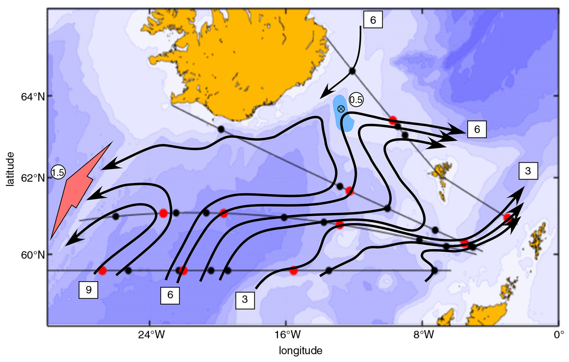
The ADCP operation on the Nuka Arctica led to many contributions. The May 2 blog was about the discovery that the Irminger Current in fact consisted of two parallel flows along the western slope of the Reykjanes Ridge. The May 7 and 9 blogs showed some beautiful examples of acoustic backscatter patterns shaped by the diurnal migrations of zooplankton. As noted before, the Nuka Arctica operated on a 3-week schedule between Greenland and Denmark. Eastbound she sailed along a constant latitude, westbound along a great circle, and at times also made a stop at Reykjavik. Thanks to these three routes west from Denmark as well as the Norröna operation between Shetland, the Faroes and Iceland Katelin Childers could construct an accurate map of the Iceland Basin of upper ocean circulation and its linkages with the Nordic Seas.
It has long been known that North Atlantic Water enters and flows cyclonically around the Iceland Basin with some water continuing into the Nordic Seas over the Iceland-Faroe Ridge. There was a long-held view that North Atlantic Water entering the Nordic Seas through the Faroe-Shetland Channel must come though Rockall Trough. This thinking had been challenged before and the repeat measurements by the Nuka Arctica confirm this. Instead, most of the Faroe-Shetland Channel water comes from the Iceland Basin west of Hatton Bank and flows east just north of Bill Bailey Bank and the Wyville-Thompson Ridge. Rockall Trough is a rather quiet region with flow north only along the continental slope. Of the ~3 Sv flow through the Faroe-Shetland Channel less than 1 Sv flows along the Rockall slope from farther south. It was probably this flow that led to the view that all water in the channel must come through the trough.
The topography at the northern end of the trough constitutes a major barrier to through-flow toward the north, perhaps especially the Wyville-Thompson Ridge. Another example of topographic control is how water approaching the Iceland-Faroe Ridge must curve to the west along the shoaling slope, and curves sharply to the east over the deepening northern slope. It is the demand for new water to replace the overflow from the Nordic Seas that forces water to cross the ridge. The map also shows a well-defined flow south along the eastern slope of the Reykjanes Ridge with only weak leakage across it.

The map shows 0-400 m transport in Sverdrup units (1 Sv =106 m3s-1). Red dots identify 3 Sv units along the four lines travelled by the Nuka Arctica and Norröna. Blue area at ridge indicates 0.5 Sv overflow through the western valley from the Norwegian Sea. The broad arrow in the west indicates a distributed flow across the Reykjanes Ridge. Consult the paper below for further details. It includes an extensive summary of earlier work in the region.
Childers, K. H., C. N. Flagg, T. Rossby, and C. Schrum (2015), Directly Measured Currents and Estimated Transport Pathways of Atlantic Water between 59.5oN and the Iceland-Faroes-Scotland Ridge. Tellus A, 67,28067 http://dx.doi.org/10.3402/tellus.v67.28067